The Three-Year Expedition
1931-34
|
|
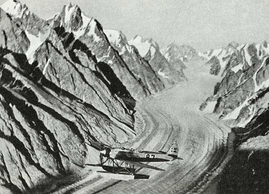
The introduction of aeroplanes and airphotographs in the survey of Greenland on Lauge Kochs Three-Year Expedition to northeast Greenland 1931-34 set new standards for arctic cartography, and in 1933 Lauge Koch conducted two recognaissance flights over the country first surveyed by the Denmark Expedition in 1906-08. |
|
|
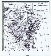
Mapping
from the air on the Three-Year Expedition. From Meddelelser om Grønland, Vol. 130, No. 1, 1940. |
|
|
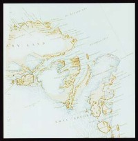
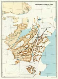
Handpainted
sketch showing Koch flights over Kronprins Christians Land in 1933. The
map belongs to the Danish Arctic Institute.
|
|
In 1935 Koch presented the results of his flights in the Journal of the Swedish Geographical Society by a comparison of two maps. Again
Koch was met with accusations of exaggerating his achievements. According
to Henning Bistrup – a veteran from the Denmark Expedition 1906-08 –
the proper counterpart to Kochs new mappings was the map of Northeast
Greenland issued by the Commision for Scienfic Research in Greenland in
1918.
|
|
|
Kochs
map of the area before flights. Journal of the Swedish Geographical Society, 1935
|
|
|
|
Kochs
map of the area after the flights. Journal
of the Swedish Geographical Society, 1935.
|
|
|
|
Northeast
Greenland (extract). The Commision for Scientific Research in Greenland, 1918.
|
|
Koch
dismissed the critique as being both unfair and emotional. The map he had
used as basis for his counterpart was the latest map of the area published
by the Geodetic Institute in 1933. Furthermore he pointed a number of
errors and inconsistencies in the map proposed by Bistrup: 1)
It shows to edges of
the Inland Ice, although the 1st Thule Expedition in 1912 had already
proved the easternmost edge to be correct. 2)
It shows the tip of Mylius
Erichsen Land as rather hilly, while the Høegh Hagens remaining sketches
of 1906 had already correctly described the area as flat. 3)
It does – for rather
obvious reasons – not portray the results obtained by Lauge Koch on the
Jubilee Expedition in 1921. “I
have sometimes”, wrote Koch, “among cartographers who have gained
their results through laborious work on sledge journeys, noticed a certain
bitterness because mapping has now been greatly facilitated through radio
and airplanes. As I have myself for several years done mapping work in
North Greenland according to the old methods, I have all qualifications
for understanding, and really do understand this bitterness.” In
the map of 1918 the routes of earlier expeditions speak of the mapping of
these region as a result of common and gradual achievement by a long line
of Danish explorers. The way the tracks of the dogsleds follow the
contours of the landscape, and the way the mountains and edges of the
inland ice are marked as insurmountable slopes, speak of the unfavourable
conditions under which the topography of Greenland was secured for Denmark
in earlier times. In this context the map becomes homage to the heroic age
of Danish arctic exploration. In contrast Kochs map comes across as a
celebration of the technological achievements of a new age of arctic
exploration, spelled out in new details and the straight lines of flight
between sharply defined topographical points.
|
|
|
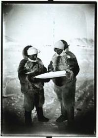
Cooperation with Greenlandic sledge drivers was an absolute necessity in the early age of Danish exploration of North Greenland. Knud Rasmussen and Inukitsoq studies the map on the 2nd Thule Expedition. © The Danish Arctic Institute.
|
|
|
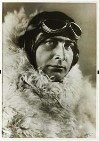
The modern pioneer. Lauge Koch in artic aviation outfit. 1933.
|
|
|
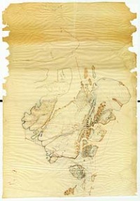
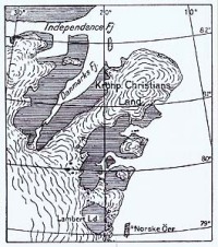
The
final map of Kronprins Christians Land after the Three-Year Expedition
1931-34. Meddelelser om Grønland, Vol. 130, No. 1, 1940. |