The Bi-centennary Jubilee
Expedition 1920-23
|
|
In the years 1921-23 Lauge Koch conducted the Bi-centennary Jubilee Expedition to North Greenland, and in the year of the bi-centennary jubilee of Hans Egedes landing in Greenland Lauge Koch made his great sledge journey along the north coast of Greenland, round Peary Land and back across the Inland Ice. On this journey Koch discovered a depression which in his opinion was the one that Peary in 1892 had mistaken for a channel. Kochs observations of the interior of Independence Bay led to considerable cartographic changes compared with Freuchens map of 1912. |
|
|
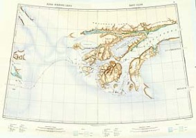
Independence
Bay as mapped by Lauge Koch on the Bi-centennary Jubilee Expedition.
Sheet 8 and 9 of the 19 sheet map of North Greenland published by the
Geodetic Institute, 1932. |
|
|
The
route of the Bi-centennary Jubilee Expedition. From Kochs popular account of the expedition published in 1925.
|
|
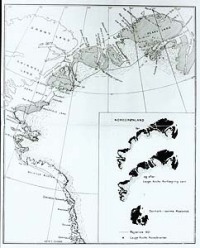
In
1935 Lauge Koch was met with accusations of wrongfully ascribing to
himself the honour af having discovered the non-existence of the Peary
Channel on the Jubilee Expedition. The accusation was especially directed
against the two inset maps in the bottom right corner showing North
Greenland before and after Lauge Kochs mapping. Koch, however, dismissed the charges pointing out the fact that Peary Land and the Greenland mainland was actually connected by a thin line in the map showing North Greenland before his mapping. According to Koch the point of the maps was to show the fact that it was he who in 1917 had been the first to shut the northern outlet of the Peary Channel. |