|
About Frederik den Femtes Atlas |
|
King Frederik den Femte was born 31.3.1723 and died 14.1.1766. He became king of Denmark and Norway in 1746 and reigned in a period of time where Denmark experienced prosperity, and art and science flourished. The dedication page in volume 1 tells us that the basis of the atlas was a gift from Jacob Tilli, minister in Kating near Eyderstedt. Jacob Tilli gives the new-born crown prins his map collection: Atlas Novus et Selectus oder Landkarten-Atlas in honour of his birth on 1723. Tilli's map collection consisted of approximately 400 maps. During the lifetime of the king, his collection enlarged considerably and ended up in 3535 numbered plates in 55 volumes. The plates show: maps, city-maps with descriptions, prospects of cities and castles, palace gardens, drawings of fortifications, of army dispositions and cannons - satiric engravings and much more. The atlas are a treasury of information and adventure for map enthusiatics, (military) historians, (garden) architects, folklorists and others with an interrest in cultural history. The atlas are a journey through countries and cities in the 18th century. To military historians it may be useful to read the book by Ib Rønne Kejlbo: Manuscript maps in the Frederik den Femtes Atlas. Most of the maps with a military theme are drawn by hand and registrared in the book. Manuscript maps in the Frederik den Femtes Atlas: Click here The last 3 volumes differ from the rest by being inventioned prints and drawings. For folklorists vol. 53 and 54 are especially interesting. Vol. 55 contains a numbers of drawings of fortifications and cannons.
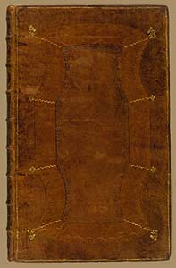
The volumes are bound in Danish Cambridge calf with gold prints and the size is 56 by 35 cm
|
|
|
|
|
|
The measures of the volumes are similar to half a copper engravings of the periode (Homann etc.). The maps that do not fit the size have either been enlarged by paper-strips or they have been folded. (The digitization of the maps do not give you a realistic impression of the size of the map)
|
|
|
|
|
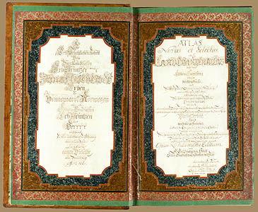
First pages of the books Similar in all volumes
|
|
|
|
|
|
Next page Only in the first volume
|
|
 |
|
| The
dedication page from volume 1
|
|
|
See additional description in Ib Rønne Kejlbo's book: Manuscript Maps in the Frederik den Femtes Atlas. See download possibility above
|
|